
About
Inside Airbnb site provides a comprehensive view of Airbnb listings for rent worldwide. This project looked at listings in the Sydney area and analysed the links between some of these data (price, area, type of home etc). It attempts to use interactive charts to show airbnb users how this data is linked, allowing consumers to make more informed choices.
The chart consists of three main parts: the map, the bubble chart and the sankey chart. 1. The map illustrates the listing density and rental length distribution in each area. The bubble chart presents the occupancy, annual income, and price/night of long-term, short-term, and overall rentals in 16 areas of Sydney. And the sankey chart provides the information about the price per night, the number of Airbnb listings and room types in 16 areas of Sydney. Below shows the work we've done.
FIND A DESIRABLE PLACE
TO BOOK OR HOST AN AIRBNB
LISTING IN SYDNEY
Data Sources:
Sydney Airbnb Data Set, Reported by Inside Airbnb on September 09 2022: http://insideairbnb.com/
Land Area, Reported by Australian Bureau of Statistics in 2020: https://dbr.abs.gov.au/
Design: Hong, Luohan, Wenlin
About: This data viz project presents the information about the Airbnb listings in 16 areas of Sydney in 2022. Three types of charts - Pie Chart on a Map, Sankey Diagram, and Bubble Chart are combined to describe how geographical locations, price per night, room types, rental terms, listing density and income of listings are intertwined and influence each other. From these visualizations, potential Airbnb hosts may have more insight into developing a listing in Sydney, and tenants may be able to make better travel and accommodation decisions.
Main Story
In the selected areas, properties of the listings such as location, density, room type, price and rental term all influence with each other. Among them, location has an obvious impact on price, listing density, rental term and average annual income of the rooms. The rental term also influences the occupancy and average annual income significantly.


What is the listings density and rental length distribution in Sydney area ?

Pie Chart On A Map
Aspect
The chart illustrates the listing density and rental length distribution in each area.
As the color distribution on the map shows, the inner Sydney and coastal areas have a higher listings density, probably because these areas are more developed in terms of tourism and attract more tourists.
For the rental length, the percentage of long-term rental is greater than short-term rentals across overall and specific areas. It can be seen that the proportion of long and short term rentals is closer in the more northern areas. While in southern areas, the proportion of long-term rentals is greater.
Data Transformation
The total listing density and rental distribution have been calculated to show the overall rental situation. Considering the size of the area varies from region to region, we divide the listing number by each area size to get the area listing density, which is used as a comparison and shown in color in the map.
Data Type

Visual Encoding
Position & Size
The pie charts are shown in corresponding location by clicking the map.
Scale
To show the listing density, color value has been scaled ordinally.
Each area's rental length distribution has been scaled linearly and show in the pie chart.
Hue, Color and Value
The color value changes from light to dark is used to show the listing density from low to high. Different colors are chosen to represent the rental length types in pie charts.
What is your best hosting choice? short-term hosting or long-term hosting?
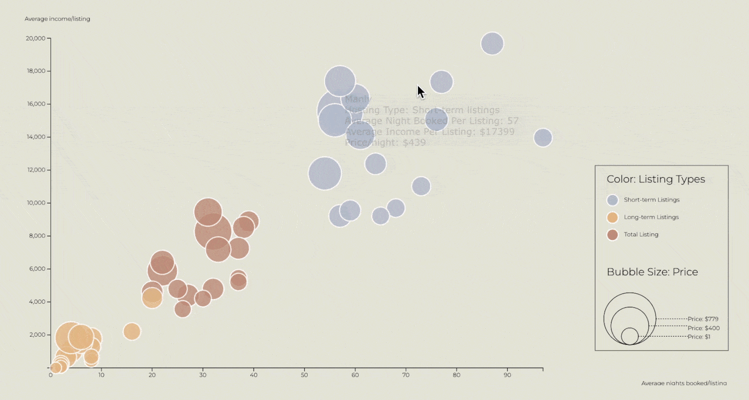
Bubble Chart
The bubble chart presents the occupancy, annual income, and price/night of long-term, short-term, and overall rentals in 16 areas of Sydney.
Visual Encoding
Position, Size and Shape
x Axis (Quantitative): average nights booked per listing in a year.
y Axis (Quantitative): average income per listing in a year.
z Axis (Quantitative): Circles with different radius indicate the average price per listing per night.
Circles (Nominal Data): Each bubble represent an area in Sydney; hover the bubble to see the detail.
Hue, Color and Value
Long-term, short-term, and overall data are represented with yellow, blue and brown respectively in the bubble chart(Nominal Data).
Scale

Data Transformation
We quote the data we'd like to use from the original InsideAirbnb Dataset(m,m1,x,x1,y,y1,p,p1). Then, calculate the data(m2,x2,y2,p2) through reasonable mathematical formulas. Below is the data transformation process of calculating long-term listings' "Activity" data.
m : the amount of all types of listings
m1: the amount of short-term listings
m2: the amount of long-term listings
x : average nights booked per listing of all types of listings
x1: average nights booked per short-term listings
x2: average nights booked per long-term listings
y : average income per listing of all types of listings
y1: average income per listing of short-term listings
y2: average income per listing of long-term listings
p : average price per listing per night of all types of listings
p1: average price per short-term listing per night
p2: average price per long-term listing per night

Why is the data of long-term listings low?
Audiences may notice that the data of long-term listings is much smaller than the overall data of all types of listings and data of short-term listings. There are some possible reasons why this situation occurs:
1. The Airbnb calendar for a listing does not differentiate between a booked night vs an unavailable night; therefore, these bookings have been counted as "unavailable" (Airbnb, 2022).
2. People have much more interests in taking long-term rentals on other apartment booking platforms (e.g. Domain & Realestate).
3. The host could privately rent out long-term listings without any records on Airbnb's dataset.
What are the nightly price and popular room types in 16 Sydney areas?
Price/night
Total Listings
Room types
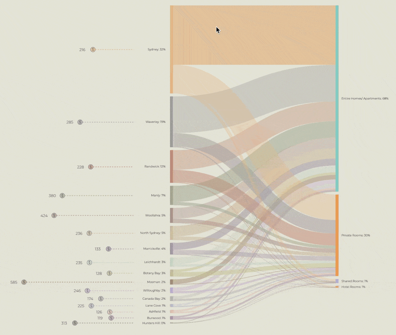
Bubble Chart
Chart Type

Present the nightly price valuewith different lengths of linesand the amount text

Present the mapping betweenroom types and the number ofAirbnb listings
Aspect
Two types of charts form this diagram: Proportional area chart and sankey diagram. Proportional circle chart enables users to quickly see the nightly price value by comparing the relative size of circles. Sankey diagram is chosen to present the data of room types and the number of listings because it is good at depicting many-to-many mapping between different domains. The listing numbers and room types are two nodes connected with links. In this digram, audiences can compare the price and see the room type distribution in each area and thus make corresponding rental decisions.
Visual Encoding
Position, Size and Shape
X Axis: 16 areas (nominal data)
y Axis: listing numbers (quantitative ratio)
Circles and rectangles with different sizes are used to indicate the price and listing number respectively.
Orientation
16 areas are arranged vertically according to the number of listings from large to small. The curves with different widths between Total Listing and Room Type indicates the proportion of each room type in a given area. Each price circle is arranged horizontally with its area.
Hue, Color and Value
16 different areas in the sankey diagram is presented as nominal data, so we applied Morandi Colors in different hues to indicate the category.